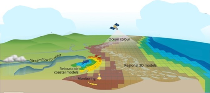
An innovative initiative aimed at understanding, monitoring, modelling and safeguarding the Great Barrier Reef, one of the world’s most iconic natural wonders.
From catchments and estuaries to reef lagoons and the open ocean, eReefs provides a comprehensive, integrated view of the reef. It operates using mathematical principles similar to a meteorological model, but instead of representing atmospheric conditions, it simulates coastal and marine waters across all depths. Through this, eReefs represents key elements such as tides, currents, marine heatwaves, nutrients, sediments, phytoplankton, coral, seagrass, and seaweed, providing important insights for reef conservation and management.
The challenge
The Great Barrier Reef, a UNESCO World Heritage Site, is a complex and delicate ecosystem stretching over 2,300 kilometres along the Queensland coast, and is under threat from numerous threats:
-
Poor water quality: from sediment, pesticide, nutrients, land catchments and river run-off
-
Extreme weather and global climatic events: from cyclones, floods, marine heat waves and storm surges
-
Biological threats: including recurrent crown-of-thorn outbreaks and coral bleaching
Where does eReefs come in
eReefs plays a significant role in the conservation and management of the Great Barrier Reef. Its data and insights are used to:
-
Monitor and assess water quality: eReefs contributes to water quality assessments, informs the GBR Marine Water Quality Report Card, and helps establish land-based water quality targets in catchments. It also supports scientific research on various reef-related questions.
-
Support strategic and operational decision-making: Policy and management agencies, regional organizations, and researchers rely on eReefs’ data, analyses, and visualizations to inform decisions across the Great Barrier Reef region.
-
Shape policy and governance: eReefs’ outputs contribute to policies integrated into the UNESCO 2050 agreement for the GBR, as well as federal and state government initiatives aimed at water quality improvement and reef conservation.
